| Topography | ||
|
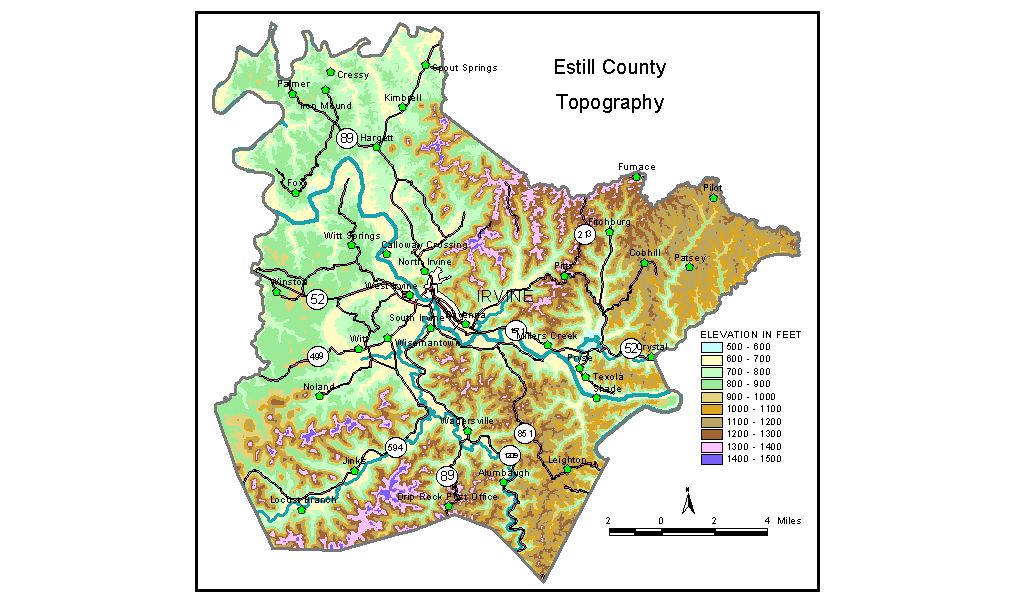
Discussion from McGrain and Currens (1978) Estill
County, in eastern Kentucky, is in parts of both the Outer Bluegrass
and Eastern Kentucky Coal Field physiographic regions. Probably the
most striking topographic feature in the county is the escarpment separating
these two regions, a rise of 500 to 600 feet between the lowland and
the highest mountains. The highest elevations are found along ridges and isolated mountains
near the edge of the escarpment in the western part of the county. The
highest point is Zion Mountain, 1,511 feet, about 6 1/2 miles southwest
of Irvine. Other high points include Happy Top Mountain, 1,500 feet;
Preacher Estes Mountain, 1,475 feet; Peter Mountain, 1,454 feet; Low
Knob, 1,450 feet; and Big Round Mountain, Buzzard Roost, and McKinney
Mountain, each at 1,420 feet. The upland area is generally rugged. Vertical
or nearly vertical cliffs commonly rim the narrow ridges and headwater
gorges. The lowest elevation, the Kentucky River at the mouth of the Red River,
is 566 feet. Nearly flat ridgetops with elevations of 800 to 900 feet
are common in the Outer Bluegrass Region. The valleys of the Kentucky
River and its tributaries in the vicinity of Irvine and Ravenna are
commonly broad and contain the largest tracts of flat land in the county. Pea Ridge, north of Wisemantown, is the core of a large cutoff meander
of the Kentucky River. Maximum elevation exceeds 840 feet, approximately
200 feet above the abandoned channel of the river. The elevation of Irvine, the county seat, is 585 feet. Elevations of other communities are Ravenna, 643 feet; West Irvine, 690 feet; and Wisemantown, 661 feet. The 7.5-minute topographic quadrangle maps that cover Estill County
are shown, by name and by index code (Kentucky Natural Resources and
Environmental Protection Cabinet) on the index
map. Previous--Next--Back to "Groundwater Resources in Kentucky"
|
||