
KGS Home
New Eastern Kentucky Geologic Map Released by KGS
Lexington, KY. (April 7, 2008) - Much useful information for community planners, energy-related industries and others interested in the geologic resources of the Hazard, Kentucky region can be found on a newly-published 30 x 60 minute quadrangle map (compiled at a 1:100,000 scale) from the Kentucky Geological Survey at the University of Kentucky.
The map and the digital data used to create it are the result of detailed assembly of digitized 7.5-minute geologic quadrangles of the area, known as Digitally Vectorized Geologic Quadrangle (DVGQ) maps.
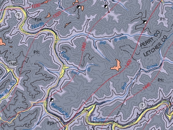
Entitled Geologic map of the Hazard 30 x 60 minute Quadrangle, Eastern Kentucky, it is compiled and authored by Tom Sparks and Warren Anderson of KGS and Lance Morris, formerly a KGS geologist now with the City of Owensboro, Ky. It is the 14th of a series of such maps developed and published by KGS.
Kentucky is geologically mapped at a scale of 1:24,000, by a total of 707 of the 7.5-minute geologic quadrangle maps. KGS has converted the original paper versions of these large scale maps to digital vector format. Thirty-two of the digital versions of the DVGQ maps were compiled to create the new map at a 1:100,000 scale. The newly compiled map has kept the accuracy and detail of the original ones used to create it while also allowing a regional perspective on the geologic setting at the new scale.
The map, encompassing an area of 1902 square miles, includes all or significant portions of the Kentucky counties of Clay, Leslie, Perry, Jackson, Owsley, Breathitt, and Knott, with minor portions of adjacent Harlan, Knox, Laurel, Lee, and Letcher Counties. The cities of Hazard, Hyden, Buckhorn, Booneville, Manchester, Vicco, and McKee are also located on the map.
The mapped area is within the Eastern Kentucky Coal Field, and extensive text on the map describes the history of the coal mining industry, as well as the types and amounts of coal potentially available. The availability of natural gas and petroleum in the region is also discussed.
Community planners will find valuable information on the map on topics from water resources, including water from abandoned underground coal mines, to geologic hazards. For instance, the text notes the potential for landslides in the area, as a result of slope instability, exacerbated by human activities such as logging, clearcutting, construction, and mining.
The digital vector files used to create this map are available from KGS on CD-ROM for $10 per individual DVGQ and can be used in geographic information systems (GIS) and other computer software. The digital data sets allow GIS users to combine the geologic map data with other data for multiple purposes, including geologic hazard mitigation and assessment of energy and mineral resources. The digital data sets can also be used to create custom maps; they are ideal for land-use development and planning.
To view this publication on-line, go to the KGS Publications & Map catalog at http://kgs.uky.edu/kgsweb/findpubsmain.asp. Enter this publication’s number, 17192, in the box next to “Enter Publication Number or SkuCode”, and to the right of this box select "exact publication id" from the pull down menu. Clicking on the “Search” button opens a new page with a link to the map.
Paper copies of the map are available from the KGS Public Information Center on the UK campus for $10 each plus shipping and may be ordered by calling (859) 257-3896 or toll free at (877) 778-7827.

A section of the Hazard map, showing the amount of detail on the publication.